UNESCO Danube Delta Biosphere Reserve Strictly Protected Zones that appear as three areas enclosed in a dotted line are also shown enlarged.
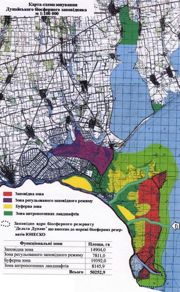 Map: Zapividni Iadry-1. The UNESCO Danube Delta Biosphere Reserve zone credited to Ukraine can be seen to consist of three small areas enclosed in dotted lines, none of them near the Bystre Channel, which has been marked with the letter "B" inside a white arrow. Original jpg version of the map is at the Ukrainian Embassy in Austria web site at www.ukremb.at/aktuell/images/map3_big.jpg, PDF version available both here and where originally published at www.ukremb.at/aktuell/images/map3_big.pdf |
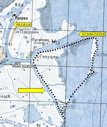 Map: Zapividni Iadry-2. Detail from the Mosaic of the Ukrainian Danube Delta, with yellow labels and dotted boundaries added, shows an enlargement of the northern portion of the UNESCO Danube Delta Biosphere Reserve in Ukraine that was presented in Map Zapividni Iadry-1. Waterways that have actual � or even the slightest potential � use as traffic corridors can be seen to have been excluded from the UNESCO Reserve � namely, the Ochakivske to its north, and a lesser unnamed channel to its west. |
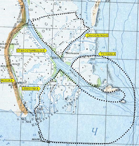 Map: Zapividni Iadry-3. Detail from the Mosaic of the Ukrainian Danube Delta, with yellow labels and dotted boundaries added, shows an enlargement of the southern portion of the UNESCO Danube Delta Biosphere Reserve in Ukraine that was presented in Map Zapividni Iadry-1. Waterways that have actual � or even the slightest potential � use as traffic arteries can be seen to have been explicitly excluded from the UNESCO Reserve � namely, the Starostambulske, Zavodnynske, Tsyhanka, Lebedynka, and Musura. There is no conceivable reason for splitting this particular region into two reserve zones, where there could have been one, other than to exempt the Zavodnynske and the Tsyhanka from any inhibition of traffic that would result from their falling under UNESCO protection. That the drawing shows no egress from the Starostambulske except across a band of UNESCO Reserve lying out in the Black Sea can only be an error � it being inconceivable that Ukraine would take care to keep so many lesser channels open to traffic while leaving the mighty Starostambulske blocked at its mouth. Romanian territory is marked by a colored line to the east of the Starostambulske at the top of the map, and then to the east of the Musura lower down. At the top and bottom of the Musura, the national boundary is marked by a dash-dot line. |
HOME DISINFORMATION PEOPLE KUCHMA PUTIN YUSHCHENKO DANUBE MAPS