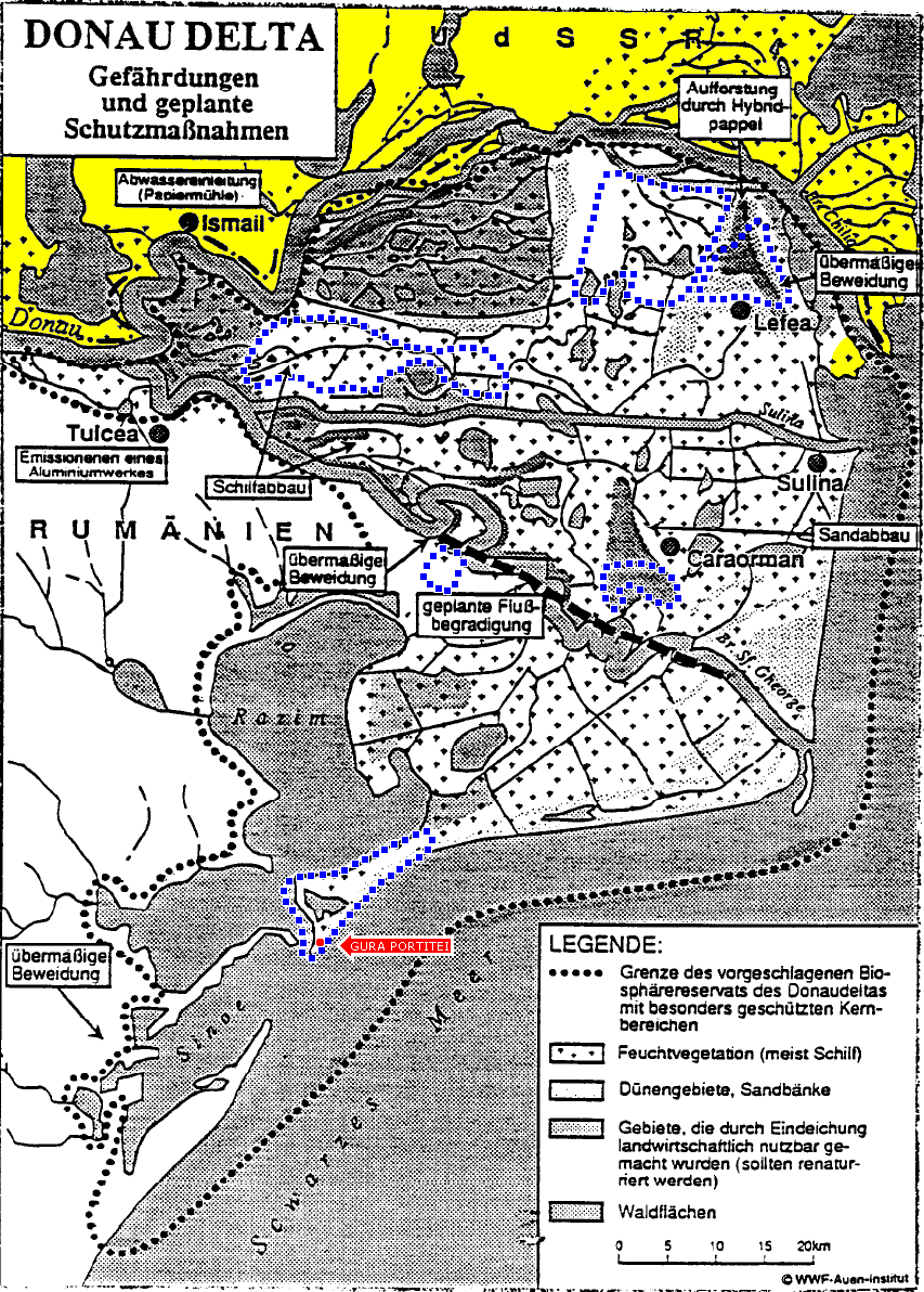
MAP: ROMANIAN DONAUDELTA 855 x 1195 gif
![]()
This map starts off from the west placing the boundary between Romania and Ukraine (colored yellow here) north of the Danube River, on Ukrainian territory, instead of in the middle of the river where it belongs. When the Ukrainian island of Little Tataru is encountered, the Romanian Danube Delta Biosphere Reserve dotted line ploughs right through the middle of it, instead of staying on Romanian territory, across the river toward the south. The land masses to the east of Little Tataru suffer the indignity of having the border cut through their middle, when in fact the border belongs south of them, again in the middle of the Danube. The most significant land grad occurs at the mouth of the Starostambulske, where the Ukrainian Dragon's Beard is placed within the Romanian Danube Delta Biosphere Reserve — it has been colored yellow in the map below to mark that error. Smaller dot-enclosed areas within the one large dot-enclosed area have been colored blue here — these are the Strictly Protected Zones which constitute some ten percent of the larger Danube Delta Biosphere Reserve. The red Gura Portitei arrow has been added, along with a red dot marking its location, to show where it is that Romania has built a tourist resort — within a Strictly Protected Zone, if this map is to be credited. However, as this map's Strictly Protected Zones do not correspond to those appearing in other maps, it may be supposed that they have been revised; perhaps these are only a first approximation. In fact, only 6 can be counted here, whereas more recent maps list 18. The heavy straight dashed line which was in the original clarifies UNESCO discussion of the Romanian project to transform the meandering George Channel which serves the environment (at the expense of shipping) into the straight George Canal which serves shipping (at the expense of the environment). The width of all channels is, of course, hyperbolized in this map — in a satellite photograph, many of them would be mere threads, and some quite invisible.
This map was originally at World Heritage Nomination — IUCN Summary, 588: Danube Delta Biosphere Reserve (Romania)
whc1.unesco.org/archive/advisory_body_evaluation/588.pdf, from which it might be guessed that the map's date is April 1991.

HOME
DISINFORMATION
PEOPLE
KUCHMA
PUTIN
YUSHCHENKO
DANUBE
MAPS