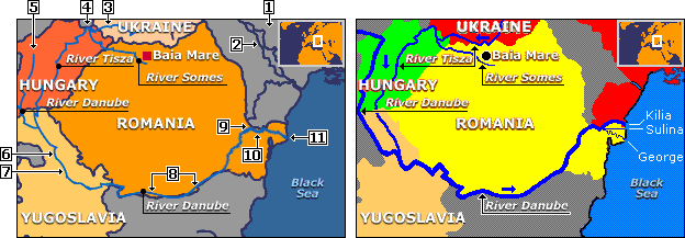
By way of demonstrating how badly BBC coverage of Danube events can deteriorate, it might be noted that in the BBC map covering the Baia Mare spill on the upper-left above, Ukraine is written off as untouched by the toxins first near the point of origin and again at the mouth of the Danube. The following eleven BBC errors contribute not only to this false impression, but also to the reader's general confusion:
Showing unnamed countries of peripheral interest in a single irrelevent-country color is permissible; what is not permissible is allocating a color to a country in one position on a map, and then giving it an irrelevant-country color when it appears somewhere else. Thus, if Ukraine is given its own color at the place that "UKRAINE" is written, it must be given the same color when it appears again toward the upper-right of the map.
Rivers irrelevant to the BBC article, like the Dnister, clutter the map when drawn, and when drawn in the same color as national boundaries, invite confusion. The Dnister line, in particular, invites the impression that it constitutes a national border as it approaches the Black Sea, when in fact Ukraine lies on both sides of the Dnister at this point, and so is continuous.
If this blue line is supposed to be the Tisza River within Ukraine, then it needs to be labelled as such, and it needs to be drawn lower so that it can form the border between Ukraine and Romania.
The peak of the Tisza needs to be shifted eastward until it touches Ukraine, otherwise it will seem that contamination flowing from the Somes River bypasses Ukraine, which it does not.
The Danube River does not have its source in Hungary, but rather arrives in Hungary from Slovakia, and before that Austria, and before that Germany.
The Danube needs to be shifted westward here so as to make a border with Croatia.
The Danube needs top be shifted eastward here so as to make a border with Romania.
The border between Romania and Bulgaria does not fall below the Danube at these two points.
Moldova (the gray shape containing the number "2") has 900 m of frontage on the Danube River, which is invisible in the BBC map, but is important becaus that frontage transforms Moldova from a landlocked country to one that has direct access to shipping on the Danube, and that therefore has maritime access to the Black Sea.
The border between Ukraine and Romania does not lie higher than the Danube at this position.
The Danube has three prinicipal mouths, which from north to south are the Kilia, the Sulina, and the George. The Kilia most deserves to be represented on a map because it is the biggest, carrying two-thirds of all Danube water. Romanian leadership, however, might prefer the Kilia to be erased from maps and blocked as a shipping channel for the reason that egress from it to the Black Sea requires passage through Ukrainain territory, thus ceding all transit fees to Ukraine. Passage through Ukrainian territory occurs because the Dragon's Beard (shown in this map as three pixels of red on the south shore of the mouth of the Kilia) belongs to Ukraine. The Sulina, in turn, is a straight Romanian canal whose importance lies in its for many years having enjoyed a monopoly on Danube-to-Black-Sea shipping. However, the BBC shows neither of these two, but only the smallest of the three, the meandering George, which happens to lie deepest within Romanian territory — as if it was the only, or the principal, mouth of the Danube.
In summary, the BBC map is not only randomly slovenly, but seems to wish to remove Ukraine from consideration in a disussion of Romania's Baia Mare toxic spill. Particularly, at the northernmost peak of the Tisza, the BBC erroneously removes the river from contact with Ukraine, and thus erroneously removes Ukraine from the harm of the toxins flowing along the Tisza. Furthermore, when these toxins finally arrive at the Danube Delta, the BBC map leaves it open to question whether Ukraine even touches the Danube, and on top of that invites forgetting that Ukraine is present anywhere in that vicinity by failing to give it its assigned color. And the BBC portraying the smallest of the three mouths of the Danube as the only mouth takes attention away from the fact that the biggest mouth, and which has the greatest potential to carry Danube shipping without harming the delta ecology, is the Kilia.
The improved map shown above on the right corrects the eleven above BBC errors, though it continues to be burdened with shapes and distances that are inaccurate.
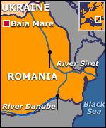
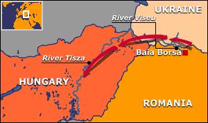
Second BBC map — bad!


